
![]()
![]()
![]()
![]()
![]()
![]()
![]()
![]()
![]()
![]()
![]()
![]()
![]()
![]()
![]()
![]()
Contents: NWS
Layout: F. Geller-Grimm
Photos: © Krabbe-Paulduro
WThe warm and dry summer of 2003 was quite a sensation in Germany and clearly showed the effects of continuous heat and lack of rain on flora and fauna. There are, however, many regions on our earth, which are permanently exposed to an extreme arid climate and which might completely lack any rain for years.
M
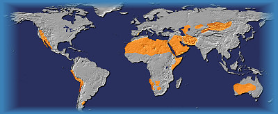
ost major deserts occur in the two belts of dry climate from 30º to 40º north and south of the equator, the so-called "Horse Latitudes". In these belts, pockets of high pressure are formed by the sinking of tropical air. The sinking air is relatively dry and rather absorbs moisture than releasing it. Lasting aridity and formation of deserts can also be the result of onshore blowing winds, which come across cool ocean-currents and thus release the majority of their moisture before reaching the shore. Examples are the Namib of southern Africa, as well as the Atacama in Chile. Location is also a factor contributing to the formation of deserts. Areas in the rain shadow of high mountains or at a great distance from the coast are often reached by little moisture only. Examples are the North American deserts or the Gobi of China.
Even though deserts are expanding worldwide because of human activities, many desert ecosystems are threatened by humans. Any interference with this complicated habitat and its inhabitants has long lasting consequences. For example, tire tracks in such a landscape will be visible for many years and overexploitation of such areas often leads to a loss of the already scant vegetation.
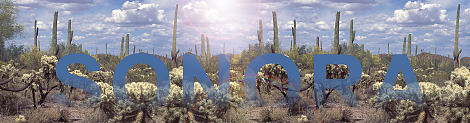
The Sonoran Desert covers an area of approx. 320,000 km² in the southwest of North America. It comprises parts of the Mexican state of Sonora, much of Baja California, south-western Arizona and south-eastern California. To the north, the Sonora borders the Mojave Desert, to the east the mountain ranges of the Sierra Madre Occidental and to the west the Gulf of California, respectively the Pacific Ocean.
 Geologically the Sonoran Desert is part of the so-called "Basins and Range Province". Characteristic are broad low elevation valleys (basins) filled with debris and rimmed by long, thin, parallel mountain ranges. Erosion by heavy rains leads to the formation of cone-shaped masses of debris called alluvial fans along the mountain ranges and where several of these fans coalesce, the resulting landform is a slope of eroded rock called Bajada. The area is drained in the west by the Colorado and Gila rivers near Yuma. However, several basins are without drainage and temporary lakes (Playas) form during the rainy season. Evaporation of the water results in the formation of salt pans.
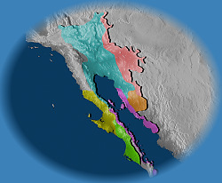
Compared to other deserts, the Sonora offers a very diverse landscape. Rising from the flat coastal stretches of the Gulf of California to elevations of up to 3,000 m in the east, the Sonoran Desert supports a large variety of microclimates and various zones of vegetation. Generally, based on differences in vegetation, six (sometimes seven) subdivisions of the Sonora are being made:
- Lower Colorado Valley or Yuma desert
- Arizona Upland
- Plains of Sonora
- Central Gulf Coast
- Vizcaino
- Magdalena